
![]()

Indianapolis / Marion County
Indianapolis serve as the geographic and
historic hub of the NRHT embracing the Indianapolis
Cultural Trail and the White River
State Park as core elements to connect trail
users with the Historic National Road and all of the
other attractions of the vibrant downtown area.
As shown below, Indy
Greenways and the Indianapolis Cultural Trail
are planned to form the route through Marion
County. See more details in the
Indianapolis
Greenways Master Plan.
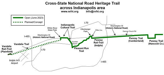
On the west side, the NRHT will use the
developing 34-mile Vandalia
Trail from Putnam and Hendricks
Counties. From Plainfield, this route
will take the planned Vandalia Trail along
the north side of the Indianapolis
International Airport and through
neighborhoods bordering the
active railroad to intersect
with the open Eagle
Creek Trail
and continue on into
downtown. Trail users access
the vibrant "business route" downtown and in
Fountain Square on the Indianapolis
Cultural Trail which also proceeds south
to connect with the Pleasant Run Trail.
Following the Pleasant
Run Trail northeast, trail users then
pick up the Pennsy
Rail-Trail in the historic Irvington
district and continue through the Pennsy
Trail in Cumberland. This is the
gateway east to the Pennsy Trail in Greenfield
and the evolving NRHT in Henry County.
Dozens of interesting sites await visitors along the trail. A dramatic entrance into downtown Indianapolis is presented by the old Washington Street bridge between the Indy Zoo and White River State Park, now a popular bike/pedestrian bridge. Other landmarks such as the Capitol, Monument Circle, Fountain Square, and the Irvington Historic District grace the route.
Open Trail
The portions of the trail in
Marion County that are
open today are part of a 20-mile continuous
trail from the Indianapolis Zoo area east into
Hancock County. This begins with a
short piece of the White River Trail
by the
Indianapolis Zoo, then crosses
the old Washington Street bridge to
downtown, the Indianapolis Cultural Trail
along Washington Street, Virginia Avenue, and
Shelby Street through downtown and Fountain
Square, the Pleasant Run Trail from Shelby
Street to Ellenberger Park in Irvington, the
Pennsy Trail in Irvington and east to
Cumberland, and 1 mile of the
Cumberland
Pennsy Trail.
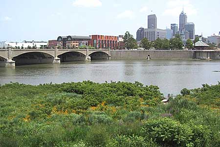
White River Trail
Bridge to Downtown
Future Plans
The Indianapolis Greenways Full Circle Master Plan includes completion of the Vandalia Trail west to Plainfield which is currently being promoted by the westside group White Lick Creek & Vandalia Trail Alliance (WLCVTA). Plainfield has already built its Vandalia Rail-Trail at the border.
Existing Features on or near the Trail
Indianapolis Airport
Indianapolis Zoo
White River State Park
IUPUI
Amtrak station
State Capitol
Monument Circle
Garfield Park
Historic National Road Interpretive Panels
Washington Street Historic District
Bona Thompson Center
Irvington Historic District
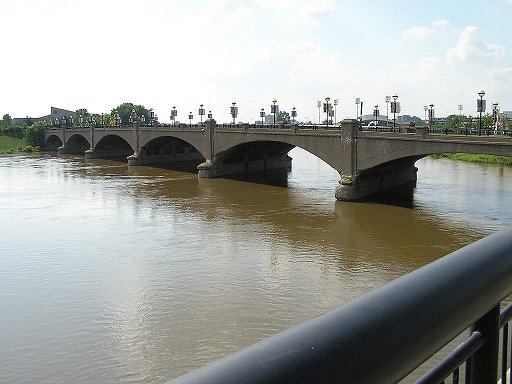
The old Washington Street
bridge (White River Trail)